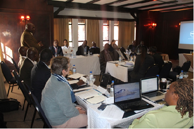
The Limpopo Basin which is shared by four countries, namely Zimbabwe, Botswana, Mozambique and South Africa is susceptible to climate change. Therefore, in taking forward the interest expressed by the LIMCOM Technical Task Team to develop compelling and credible evidence of the environmental changes in the Limpopo River Basin, including their causes and impacts, as well as to demonstrate the urgency to address negative changes, the workshop was aimed at defining the scope and focus area of the Atlas. The Atlas which will be targeted at policy makers and the general public is expected to raise awareness and generate action and intervention at local, national and regional levels. The Atlas is to use all the existing information, transfer it into visual and user friendly formats and use that to communicate with the decision makers.
The following were some of the expectations that were brought to light by the participants: not only gaining a deeper understanding of the Atlas but to be able to address the needs of the communities in the Basin, to share experiences with other participants on Atlas development, coming up with a shared vision of what the Atlas should cover, coming up with a product that will influence decision making in the Basin, coming up with a clearly defined Atlas and knowing who the target audience will be.
Mr Zvikomborero Manyangadze from the Ministry of Environment, Climate and Change who on behalf of Mr G Mawere (Commissioner of LIMCOM) in giving the welcome remarks, highlighted that the Atlas will be a useful tool for research, academic purposes and stakeholders.
During the first session aimed at setting the scene for the workshop, Mr Michael Ramaano, GWP SA Regional Programme Officer, gave an overview of GWP-SA. During his presentation he pointed out that since climate change cuts across National boundaries, negotiations for transboundary Basins should consider climate change impacts. His presentation was followed by that of Mr Nkobi Moleele, Chief Scientist at RESILIM who alluded to the Risk and Vulnerability Assessment of the Limpopo River Basin they carried out in order to locate areas of high exposure and vulnerability. The assessment aided in bringing to light how exposed the ecosystem is to climate change and also pointing out its adaptive capacity. The morning session included sessions by Mr Clever Mafuta, Africa Coordinator for GRID-Arendal, Mr Bernardas Padegimas also from GRID- Arendal, who illustrated the various ways that an atlas could be used in innovative ways of communicating in order to appeal to the target audience.
During the session aimed at helping understand what has already been done and clearly defining the added value of the proposed Basin Atlas, Mrs Egline Tauya, Head of Environment and Water Programme presented on the Zambezi River Atlas experiences, challenges, opportunities and usefulness. She reiterated the importance of identifying experts with appropriate skills for the development of an Atlas, conducting research and writing and also using appropriate and credible sources. She also highlighted that the opportunities of developing the Atlas entailed providing a spirit of basin-wide cooperation in economic, social, cultural and political issues and also provoking the need to take serious actions in development of resilient strategies in view of the environmental changes.
During his presentation on GIS and Earth observation system in Southern Africa, Mr Isaac Kusane, Project Manager, noted that the contribution that MESA could give to the drafting of the Limpopo Atlas would be providing expertise participation, thematic experts, provision of relevant remote sensing data and products which include droughts products, flood monitoring products, agriculture monitoring products and wildfire monitoring products.
Towards the end of day one, group discussions were carried out on the following aspects; land, water resources and biodiversity. Day two was marked by the presentations given by each group on their area of focus and the following issues were raised; in picking up the hotspots it is imperative to look at the Vulnerability Assessment studies that have been done in the Basin, take note of how the Atlas is going to be evaluated to assess the impact on the target audience and the need to come up with a certain criteria on how to choose hotspots.
In mapping the way forward and discussing on the main building blocks towards developing the Limpopo Atlas it was noted that there was a need to look at the general overview of the Limpopo Basin and assess what exactly is changing, to ensure that there is ownership of the product as a way of engagement and also look at who will author the Atlas. Additionally, complex data need to be accessed and a strategy to accessing that data is needed. There is a need to also engage with the target audience and to be able to package the information. Another key issue raised was the need to monitor and evaluate the communication plan to assess the impact of the Atlas.
