
The TDA was developed under the Management of Competing Water Uses and Associated Ecosystems in Pungwe, Buzi, and Save Basins (GEF-BUPUSA) project, being funded through a USD 6 million grant from the Global Environment Facility (GEF) and implemented in the basins by the International Union for Conservation of Nature (IUCN). Global Water Partnership Southern Africa (GWPSA) is the regional executing Partner supporting the two governments.
“A central element of the GEF project, the TDA was developed to provide a shared understanding of the basins and address some environmental concerns in the basins,” says Mr. Elisha Madamombe, GEF-BUPUSA Regional Project Coordinator and BUPUSACOM Interim Executive Secretary. This was done by analyzing the root causes and impacts of challenges identified through the GEF Causal Chain Analysis (CCAs) framework and assessing their environmental and economic consequences.
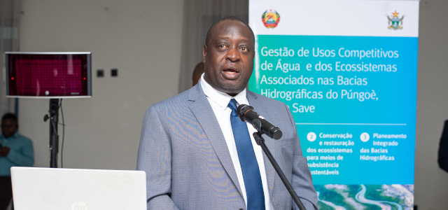
“The TDA, SAP, and NAPs are key to mobilizing resources for the development of the BUPUSA River Basins”, says Mr. Elisha Madamombe, (GEF-BUPUSA Regional Project Coordinator and BUPUSACOM Interim Executive Secretary). Photo Credit: GEF-BUPUSA Project
The TDA is built upon the findings from a series of studies and causal chain analyses conducted within the BUPUSA river basins. These CCAs established that the population in the BUPUSA Tri-basin is vulnerable to a combination of social, economic, and environmental factors that interact with climate change. The environmental challenges identified in all three basins are similar and interrelated. The majority of these challenges have the same underlying and root causes and are largely attributed to inappropriate resource use and practices.
The analysis identified five underlying drivers that contribute to all the above-mentioned priority environmental problems, which are reduced availability of water, deterioration of water quality, land degradation, changes in flow regime, and an increase in extreme climate events.
Climate change is the major environmental problem within the basins, which have, over the years, suffered from extreme climate effects such as floods, droughts, and cyclones. Climate change is expected to amplify other already existing water resource challenges, including reduced water availability. Droughts in the basins are only partly associated with deficient or erratic rainfall leading to poor harvests, and thus reduced income-earning opportunities and food security, especially in the subsistence farming sector that is predominant in the basin.
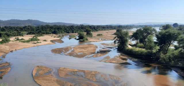
High siltation levels on the Save Rive at Birchenough Bridge, Zimbabwe, due to poor upstream catchment management or land use practices. This has resulted in a reduction in water available for utilisation. Photo Credit: GEF-BUPUSA Project
Reduced availability of water is partially related to climate change, and attributable to human factors, such as unsustainable land and natural resources use, population increase, and water-use patterns across the key sectors of agriculture, mining, urban and domestic supply, energy, and insufficient hydraulic infrastructures for water storage.
Land degradation is considered the third most pressing issue for the Buzi and Pungwe basins, and the second most important one in the Save basin, with the degree of severity being significant to severe. The degradation of land, coupled with the effects of climate change, results in lower yields. This forces people to expand cultivation into marginal areas such as steep slopes, riverbanks, and wetlands. This is one of the main drivers of land degradation, thereby continuing and aggravating the cycle.
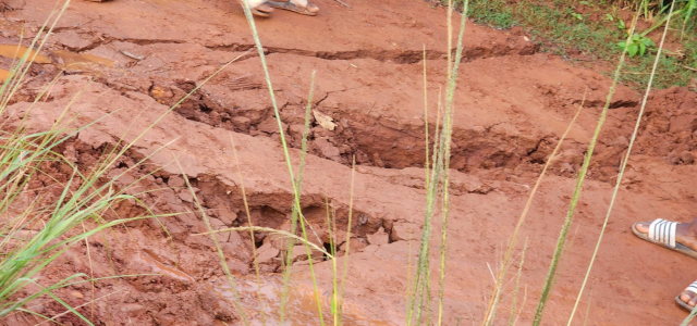
Landslide in Chadzuka village Manica in Mozambique along the Pungwe River, leading to land degradation. Photo Credit: Moses Makwanise- IUCN
The causes of reduced water quality are often the same as those for land degradation and these are largely driven by the same three sectors: agriculture, mining, and urban and domestic water supply. Poor land management has altered the conditions of the land, affecting its interactions with water, and resulting in changes in water quality, which has far-reaching consequences on the health and integrity of riparian and aquatic ecosystems.
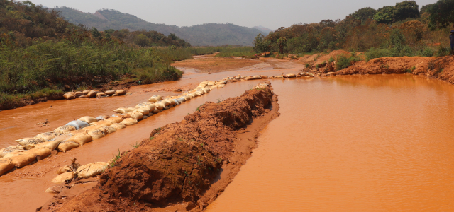
Unsustainable mining practices within Penhalonga along the Save River, Mozambique, compromising the quality of water in the basin. Photo Credit: Davison Saruchera
River flow is critical in sustaining the ecosystems as these supply energy and nutrients to sustain the food chain in the ecosystems. Increased abstraction of water for agriculture, increased water storage and withdrawals for domestic and industrial use, and unsustainable mining methods are well known for disrupting the natural flow of water in the basins. Overall, changes in river flow have been ranked as the third most important in Save, and the fourth most important in the Buzi and Pungwe.
The CCAs also identified five underlying drivers that contribute to all the above-mentioned environmental problems. These include population dynamics, land use change, poverty, climate change, insufficient governance capacity, and transboundary coordination.
Population growth, urbanization, and increased demand for goods and services contribute to environmental challenges. Land use change, driven by factors such as agriculture and artisanal mining, affects sediment dynamics, water quality, and biota distribution. Poverty, prevalent in the basins, is a key driver, influencing resource use patterns and exacerbating environmental issues. Climate change projections indicate a drier, warmer future with increased flood and drought events, posing additional challenges. Insufficient governance capacity and transboundary coordination hinder sustainable basin management.
The BUPUSA TDA, which is set to be finalized in 2024, informed the Strategic Action Program (SAP) and the National Action Plans (NAPs), which are also being developed under the same project. The SAP consists of priority interventions and investments to address the problems identified by the TDA at the transboundary level. The basins’ NAPs will complement the SAP in addressing the gaps identified in the CCA at the national level while providing interventions geared towards improving Integrated Water Resources Management (IWRM).
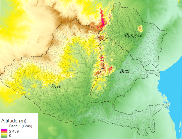
Map showing the BUPUSA basins. They all drain into the Indian Ocean. Photo credit: GEF-BUPUSA Project
The Buzi, Pungwe, and Save River basins are exclusively shared by Mozambique and Zimbabwe. The three basins are located along the Beira corridor, an important economic corridor that links Beira harbour to the hinterland. Given the challenges identified, the need for a coordinated approach to remedying these issues cannot be overstated. The GEF- BUPUSA project is, therefore, supporting the two riparian countries (Mozambique and Zimbabwe) to strengthen transboundary cooperation and management of water resources and associated ecosystems for improved water security, climate change resilience, and sustainable livelihoods in the 3 shared basins.