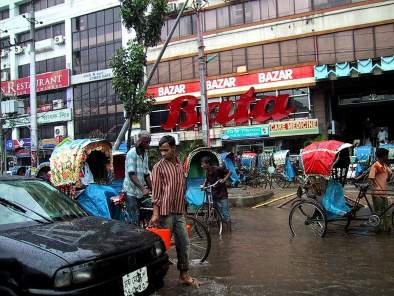
Dhaka experiences about 2,000 mm of rainfall annually, of which almost 80% falls during the monsoon. The main natural hazards affecting Dhaka include floods, which are associated with river water overflow and rain water stagnation.
Dhaka is the capital of Bangladesh with a population of around 20 million. The city is surrounded by a network of rivers: the Buriganga on the south-west, the Turag on the north-west and the Balu on the north-east and the Shitalakhya on the south. The city is more vulnerable to flooding due to heavy and unpredictable rainfall but also because its drainage capacity is decreasing due to unauthorized settlements and illegal occupation of wetlands by land grabbers.
The problems, consequences and cause effects relations are given in the matrix below:
| Problems in the Dhaka drainage system | Causes of Urban Flooding | Effects of Urban flooding |
|
- unplanned urbanization and expansion of the urban areas within the urban fringe, - increase of in built-up areas and metal roads and accelerate land run-off, - filling up of low-lying areas of surrounding the Dhaka city to construct buildings, with no or little provision of drainage, |
- Excessive Rainfall due to climate change |
- Trouble in traffic movement |
In the study a flood risk management framework has been developed which include pre-flood prevention, risk mitigation and flood preparedness. Adaptations to climate change and to economic development are important drivers in designing flood management schemes. Flood risk management is strongly related to spatial planning: the location of new developments, flood proof structures and space for rivers. Risk communication is considered as a valuable way to promote flood awareness and to improve flood preparedness of the citizens.
The study synthesized the relevant information from different available plans, programs, reports and scientific literature. To explore the existing situation of flood protection and storm water drainage management system, a field survey was conducted by a team consisting of multidisciplinary professionals.
(Photo: Prince Roy)

